FORENSIC WEATHER CONSULTANTS, LLC
2400 Western Avenue, Guilderland, N.Y. 12084
(518) 862-1800 (Phone)
Tax ID: 26-4625570
1. The Agreement.
This Retainer Agreement (“Agreement”) sets forth the terms and conditions under which Forensic Weather Consultants, LLC (“us”, “we” or the “Company”) shall provide weather consulting services to you, the client (“you” or “Client”) in connection with Client’s investigation and/or services. The parties’ engagement shall commence upon the Company’s receipt of the agreed terms, completed Weather Request Form, or other communications from the Client, and confirmation from Company that no conflicts exist. An initial deposit/retainer fee in the amount of One Thousand, Five Hundred Dollars ($1500.00) is due upon retention, unless otherwise indicated by the Company. The agreement for this case shall continue until terminated by either party hereto.
2. Services.
Company agrees to perform certain services (collectively, the “Services”) pursuant to the terms set forth herein. When a retainer agreement is completed, submitted and accepted by the “Company”, a minimum non-refundable charge of Five-Hundred Dollars ($500.00) will be applied to the invoice.
A. Weather Records, In-Depth Analysis and Consultation:
Company shall gather various weather records, reports, and data from stations near and/or surrounding the Location of Interest (aka the “Incident Location”) as designated in the Weather Request Form or other communication. Company shall determine the weather conditions (and ground conditions if pertinent) that existed at the Location of Interest during the period of time requested and/or leading up to and including the day and time period set forth by Client. The data shall be obtained from a variety of sources including, but not limited to, daily weather observations, hourly surface observations, Color Doppler Radar images zoomed in over the Location of Interest, cooperative observer station reports, National Weather Service bulletins, advisories, warnings, forecasts, and various other pertinent records, programs, reports, and data. Unless specifically requested by Client, all records will be non-certified records. Company may also provide Client, upon request, a detailed written expert report of the Company’s findings for the Location of Interest. Weather records and data will be delivered to Client electronically if requested. Upon conclusion of the initial analysis, Company will contact the Client to discuss our findings verbally. In most cases, the estimated turnaround time for the services above is approximately Five (5) to Ten (10) business days after the Retainer Agreement is received and accepted by the Company. If rush service is needed, see section 2(d) below.
B. Detailed Written Report:
If requested by Client, Company shall prepare a detailed typed expert report summarizing Company’s findings and conclusions. The written report will vary in length depending on the type of case and amount of information. The report will include a detailed analysis setting forth, in Company’s expert opinion, the weather (and ground conditions if pertinent) at the Location of Interest leading up to and including the applicable day/time period, including the facts, figures and other conclusions and how such weather conditions relate to the incident/alleged incident in question.
C. Certified Weather Reports:
If requested by Client, Company shall order and provide certified weather records if they’re available. Certified weather records shall be certified by the applicable agency, agencies of the federal government of the United States, and other entities. Client acknowledges that certified weather records cost an additional fee(s) beyond the Fees, as hereinafter defined, and that such additional fees for certified weather records shall be paid by Client together with the Fees. The cost for certified records varies from case to case depending on various factors, including volume, the number of days needed, and the types of data
D. Rush and Super-Rush Service Basis:
If requested by Client, Company shall use its best commercial efforts to provide the Services to Client on a Rush service basis (“Rush Service Basis”). Any Services provided on a Rush Service Basis shall be billed at a rate equal to One and One-Half times the meteorologist’s Hourly Rate. Company can provide its Services requested on a Rush Service Basis to Client within Three (3) to Four (4) business days provided, however, Client acknowledges and agrees that the time periods set forth in this Section 2(d) are only estimates made by Company and do not constitute a representation or warranty of any kind, nor shall Company’s failure to render the Services to Client within such time periods constitute a material breach. If requested by Client, Company shall use its best commercial efforts to provide the Services to Client on a Super-Rush service basis (“Super-Rush Service Basis”). Any Services provided on a Super-Rush Service Basis shall be billed at a rate equal to Two times the meteorologist’s Hourly Rate. Company can provide its Services requested on a Super-Rush Service Basis to Client within One (1) to Two (2) full business days provided, however, Client acknowledges and agrees that the time periods set forth in this Section 2(d) are only estimates made by Company and do not constitute a representation or warranty of any kind, nor shall Company’s failure to render the Services to Client within such time periods constitute a material breach.
E. Affidavits, Document Review, Additional Consultations and Services:
Upon request by Client, Company shall review, prepare, and provide notarized affidavits to Client based upon the information obtained by Company in accordance with rendering the Services. Company will also review other documents and materials at Client’s request including, but not limited to, attorney-prepared documentation, photographs, affidavits, witness statements, EBT’s and deposition transcripts. Phone consultations and/or additional consulting shall be billable in 10-minute increments at Company’s Rates outlined in this agreement.
F. Expert Testimony and Depositions:
Upon request by Client, Company may also provide expert testimony or deposition services as part of the Services. Any Services provided by the Company in this paragraph shall be pursuant to the requirements and fees set forth in section 7(c). Reservation of dates for Expert Testimony and/or Depositions will only commence upon receipt of the upfront testimony or deposition deposit.
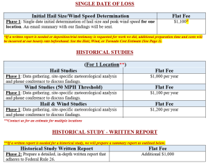
G. Flat Fee Options for Initial Hail Size and Wind Speed Determinations, and Historical Hail and Wind Studies:
H. Data Fire, Thumb Drive/DVD and Redundant Cloud Storage Backup:
A one-time $49.00 data file, thumb drive/DVD and redundant cloud storage backup fee will apply to each assignment.
3. Acceptance of Electronic Agreement.
The Parties hereby acknowledge and agree that each request electronically submitted by Client using Company’s website is a legally binding agreement, and that the Parties agree to be bound by all of the terms and conditions set forth therein.
4. Commencement of Services.
Notwithstanding anything herein to the contrary, the execution of this Agreement shall in no way obligate Company to provide any Services to Client unless and until Client electronically submits a Retainer Agreement and Agrees to Terms using Company’s website(s) in accordance with the terms and conditions set forth herein, and until Company accepts the assignment upon completion of a conflict check.
5. Term.
This Agreement will commence when the “Company” accepts the assignment from “Client” and will continue until terminated by a Party in accordance herewith.
6. Termination.
Either Party may terminate this Agreement at any time without cause by giving the other Party at least ten (10) days prior written notice. Upon termination, all duties, responsibilities, and other obligations of the Parties set forth herein shall terminate; provided, however, that any Fees and all other costs due to Company and then outstanding shall be paid by Client within ten (10) days of the date of the termination notice. Upon termination of this Agreement, Company shall return or destroy all documents, statements, records, materials, and similar documents to Client in their possession, if any, within fifteen (15) days of the date of the termination notice.
7. Hourly Rate; Fees.
A. Hourly Rate:
Unless Client elects for the Services to be provided by Company on a Rush Service or Super Rush Service Basis as stated in Section 2(D), Client agrees to pay Company certain fees (the “Fees”) for the Services at an hourly rate of Three-Hundred Thirty Dollars ($330.00) per hour. The “Hourly Rate” shall either be billed in 10-minute increments against the initial deposit/retainer fee, deposit/retainer fee replenishment, or billed to the Client via an Invoice. Client acknowledges and agrees that the Fees may not include all costs for Company providing the Services; additional costs may be charged for records, certified weather records and other Services and/or data so requested by Client. Company agrees to refund any unused portion of the deposit/retainer fee upon written notification that the assignment has concluded.
B. Invoices; Payment:
Unless otherwise indicated by the Company, an initial deposit/retainer fee of One Thousand, Five-Hundred Dollars ($1500.00) is required to open a new file. This deposit/retainer fee can be paid by credit card on the company website(s) or by phone, or by sending a check to the Company’s office. Upon completion of the Services set forth in each request, Company shall provide Client with an invoice for all Services provided. The invoice shall set forth the Fees owed plus all other expenses incurred. The Fees shall be paid by Client by check, credit card or other immediately available funds within thirty (30) days of receipt by Client. All credit card payments are subject to credit card processing fees.
C. Expert Testimony and Depositions:
Requests for live trial testimony, videotaped testimony or deposition testimony must be made more than 7 business days prior to the requested testimony or deposition date.
Fee for live trial, mediation, or arbitration testimony: $3600.00** per day.
**A full deposit must be made more than 7 (Seven) days in advance of the testimony date. A non-refundable short-notice fee of $1000.00 will be required in addition to the rates above if we are notified or requested for trial 7 (Seven) days or less before our anticipated testimony date.
The Expert Testimony Fee per Day Includes:
- Blocking off 1 (ONE) day for testimony, including our availability for court the entire day.
- Travel time from portal to portal on the day of testimony.
- Preparation for testimony on the reserved testimony date.
Note: Costs for gas, tolls, parking, hotel accommodations, rental car, train tickets, or airline tickets are not included. Time spent preparing for testimony will be invoiced in ten-minute increments at the experts’ regular hourly rate. These will be invoiced separately to the client.
Videotaped Trial Testimony:
**If remote/virtual trial testimony is requested, an $1800.00 virtual testimony deposit will be due to reserve a 4-hour block if received more than 7 days before virtual testimony. A $2800.00 virtual testimony deposit will be due if it is received 7 days or less before virtual testimony. Any time spent beyond the 4-hour reserved block will be invoiced at the rate of $430.00 per hour.
Fee for Depositions:
The hourly rate for Deposition Testimony is $430.00 per hour with a two-hour minimum. Travel time from portal-to-portal will be invoiced at the experts’ regular “Hourly Rate”, plus travel expenses. Deposition preparation time/expenses will be invoiced to our “Client” separately at the experts’ regular “Hourly Rate”.
- If the deposition is cancelled or postponed the same day as the scheduled deposition, then the full two-hour minimum fee will be due to Forensic Weather Consultants as a short-notice cancellation, in addition to any non-refundable travel expenses.
- The “Client” will be responsible for any fees or invoices not paid by the deposing party within 30 days of the invoice.
8. Representations and Warranties of Client.
Client represents and warrants to Company that:
(a) Client has the full legal right, power, and authority to enter into this Agreement and to fully perform and satisfy all of its obligations hereunder; and
(b) This Agreement, upon execution, shall constitute a valid and binding agreement of Client enforceable against Client in accordance with its terms.
9. Notices.
Any notice, request, demand, waiver, consent, or other communication which is required or permitted hereunder shall be in writing and shall be deemed given only if sent by registered or certified mail or by Federal Express or other comparable overnight mail service, postage prepaid, to the respective address of the Parties set forth above.
10. Indemnification by Client.
Client shall indemnify, defend, and hold harmless Company and its members, managers, officers, agents, employees, and affiliates from and against any and all claims, damages, liabilities, costs, and expenses, including reasonable attorneys’ fees and disbursements, arising out of any breach or, in connection with a third-party claim, alleged breach of any representation, warranty, covenant or agreement made by Company herein which claim is reduced to final judgment or settled with consent.
11. Disclaimer; Limitation of Liability.
COMPANY EXPRESSLY DISCLAIMS, AND CLIENT HEREBY EXPRESSLY WAIVES, ANY WARRANTY, EXPRESS OR IMPLIED, WITH RESPECT TO ANY OF THE SERVICES CONTEMPLATED UNDER THIS AGREEMENT. COMPANY SHALL HAVE NO LIABILITY WHATSOEVER FOR CONSEQUENTIAL, EXEMPLARY, SPECIAL, INCIDENTAL OR PUNITIVE DAMAGES. IN ANY EVENT, THE LIABILITY OF COMPANY TO CLIENT FOR ANY REASONS AND UPON ANY CAUSE OF ACTION SHALL BE LIMITED TO THE AMOUNT ACTUALLY PAID TO COMPANY UNDER THIS AGREEMENT. THIS LIMITATION SHALL APPLY TO ALL CAUSES OF ACTION IN THE AGGREGATE INCLUDING, WITHOUT LIMITATION, BREACH OF CONTRACT, BREACH OF WARRANTY, NEGLIGENCE, STRICT LIABILITY, MISREPRESENTATIONS AND OTHER TORTS.
12. Confidentiality.
Each Party agrees to keep secret and retain in the strictest confidence and shall not disclose to any third party (without the prior written consent of the other Party or except as required by law) and shall not use or exploit, or authorize any third party to use or exploit, in any manner or medium: (a) any ideas or concepts related to the Services provided hereunder; (b) the terms of this Agreement, or (c) any information which a Party may provide to the other Party or of which the other Party may become aware in connection with the businesses of a Party or any of its affiliated companies.
13. Miscellaneous.
(a) Independent Contractor: Client acknowledges that this Agreement constitutes an agreement whereby Client is engaging Company as an independent contractor and not an employee, and in no event shall this Agreement be construed to create any employment, agency or joint venture relationship between the Parties.
(b) Assignment: Neither Party may assign this Agreement or any of its rights or obligations hereunder without the prior written consent of the other Party.
(c) Entire Agreement: This Agreement may not be modified or amended except in writing signed by the Parties hereto. This Agreement incorporated herein contain the full understanding of the Parties with respect to the subject matter hereof and supersede any and all previous agreements between the Parties.
(d) Enforceability: The Parties acknowledge and agree that all provisions of this Agreement are reasonable and valid in all respects and that if it is determined that any provision hereof is invalid or unenforceable, the remainder of the provisions shall not thereby be affected and shall be given full effect, without regard to the invalid portions.
(e) Choice of Law and Forum: This Agreement shall be governed by and construed in accordance with the laws of the State of New York applicable without regard to principles of conflicts of law. Each Party hereby consents to the jurisdiction of any state or federal court located within the County of Albany, State of New York or the Northern District of New York.
(f) Client’s Remedies: Client agrees that its rights and remedies in the event of any alleged breach of this Agreement by Company will be limited to the right, if any, to recover money damages in an action at law pursuant to the terms of this Agreement, and in no event will Client be entitled by reason of any such breach to seek injunctive or other equitable relief.
(g) Counterparts: This Agreement may be executed in counterpart signatures all of which, when taken together, shall be deemed to constitute one and the same instrument.
(h) Survival: All provisions of this Agreement relating to warranties, confidentiality, choice of law and forum, and indemnification shall survive the expiration or earlier termination of this Agreement.
The “Client” completing this Agreement is a duly authorized representative of their company, business or corporation and has the authority to execute same effective the date these terms are accepted.
14. Use of Information, Weather Records, or Reports.
“Client” explicitly agrees not to use or reference any of the records, images, data, findings, information, tables, conclusions, or any report that was provided by Forensic Weather Consultants for any other case, claim or incident location other than this specific incident and incident location. Use of this information for any other claim or case is expressly prohibited.
15. Daubert or Frye Challenge. In the very unlikely circumstance where a challenge to the Daubert Standard or Frye is made against any expert from the Company, you agree to immediately notify the Company and the expert witness within One (1) Business Day of receipt of the motion and assist the Company and Expert with drafting and providing a response.
Close